We woke up to a cloud in the valley at the Flock Hill Lodge, and we all filtered into the kitchen and made breakfast and lunch for the day. We got the news at 8:30: today - we were mapping. We were apprehensive. Mapping? Mapping on the North Island was marked by 5 different kinds of precipitation. But today we were set for clear skies and great visibility. After a quick lesson about geomorphology mapping and different symbols used for marking gullies, scarps, terraces, and landslides, we all piled into our respective cube-shaped vehicles and set out for a lovely field day, map boards in hand.
Our first stop was on the side of the road next to a valley on the way to Cave Stream. Here we looked at the different terrace features that were present in the valley. We also looked at all of the different gulley features higher up on the slope and mapped both gullies and the attached alluvial fans below. We then hiked up a larger hill behind us, so we could get a better vantage point.
Up the slope, we confirmed what we thought about the terraces next to the highway, as well as mapped some new terraces down the slope next to another stream. After a few minutes, we realized the features we were standing on were giant landslides! After a few more minutes spent scoping out the morphology of the area from a high vantage point, we made our way down to the cars and drove to the next stop, toward the Cheeseman Ski Area.
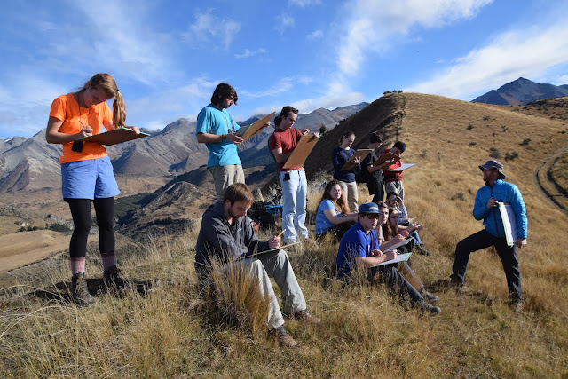

On the gravel road toward Cheeseman, we hopped out and noticed that we were close to a very large hill with maroon vegetation on it. It looked like a terrace, but it was much larger and more eroded than the others we had seen. We mapped it out and continued to look around. We then realized that we were standing on another terrace, and there was another level of terrace that went down to two streams that flanked us on either side. We drew them in on our map, and some of us headed down the road, while others walked farther out onto the lower terrace and tried to determine if the land on the other side of the valley was the same height as what we were standing on. It was. After the group all joined back together, we enjoyed a nice lunch on Texas Flats, which was halfway to Cheeseman.

After lunch, we mapped some alluvial fan deposits on the hillslope and another set of terraces above a stream. We then made our way back towards where we began, stopping to map terraces we hadn’t yet seen up close. After we had many features represented on our maps, it was time to begin comparing terraces to decide the succession in which they were made. We used terrace height, vegetation cover, sinuosity, and the angle of slope to solve this mystery. At one point, we had a passionate discussion about whether we were standing on T2, T3, T4A. or T4B! Most people agreed upon T4A, some stuck to their guns on their original theories, and others introduced T5. After a few last stops to get all the information we needed, we headed back to the Flock Hill Lodge.

Back at the Lodge kitchen, we all sat down to polish our mapping projects. We also wrote explanations of how the terrace structures were formed (river deposition and erosion), and how we figured out their succession. We all finished with some time to hang out before dinner, which was tasty garlic bread, noticeably white rice, yummy vegetable stir fry, delicious potatoes, and a saucy chicken dish. After leaving dinner, most of us played a few games, including spoons and mafia. This was a great end to a day spent working on a super fun assignment. We are happy to say this has replaced the association of mapping and very intense weather.
The Mapmeisters,
Liam and Nora
The Mapmeisters,
Liam and Nora
Comments
Post a Comment